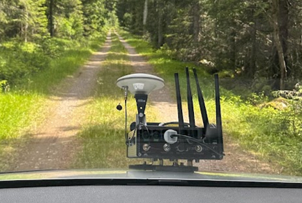
Two new SmartForest publications just got showing how sensor-based and AI-supported approaches can help improve the monitoring, classification, and maintenance of forest roads using the mobile platform RoadSens.
Forests are primarily made accessible through the forest road network, enabling management and utilization of timber resources. But forest roads also cause fundamental costs on forest management and need to follow technical requirements to mitigate environmental impact. Detailed and frequently updated information on road characteristics are therefore a fundamental component of sustainable forest road management.
In “Toward automation in forest road classification: opportunities and limitations of geometry extraction from a mobile sensor platform“, Helle Ross Gobakken, Mostafa Hoseini, Stephan Hoffmann, and Rasmus Astrup, explore how RoadSens can be used to automatically extract road geometry and exemplarily validate technical classification requirements of the Norwegian forest road standard. The study shows that automated sensing can provide a cost-effective alternative to manual surveying, while also highlighting challenges in width detection and classification accuracy under different vegetation conditions.
In “Mapping forest road surface deterioration: detection, localization, and assessing maintenance features with the near-field sensor platform RoadSens“, Stephan Hoffmann, Mostafa Hoseini, Moritz Wingartz, Mahmoud Rajabi, Helle Ross Gobakken, and Rasmus Astrup present an automated pipeline for detecting and mapping six maintenance-related road surface features, including potholes, wheel ruts, gullies, stones, washboards, and vegetation and rating them in a three-class traffic light system.
The results demonstrate the technical feasibility of combining near-field sensing, geo-referencing, and object detection models to support data-driven maintenance planning.
Together, these studies show how RoadSens is moving toward a more automated and data-driven approach to forest road management — from assessing road geometry and technical class to identifying deterioration and maintenance needs. This is an important step toward more up-to-date road data, better maintenance prioritization, and improved transport planning in forestry.